Infrastructure Modelling
Engineering-ready terrain and bridge models for flood, structural, and construction analysis.

Orthomosaic Drone Surveys
High-resolution aerial mapping for engineering and planning
We produce spatially accurate orthomosaic imagery to support engineering analysis, planning, and infrastructure workflows. These datasets provide a reliable visual and spatial foundation for site understanding, earthworks planning, asset mapping, and integration with GIS and CAD environments.
Orthomosaics are delivered as georeferenced outputs suitable for measurement, overlay, and comparison against design models or historical datasets. Where required, imagery can be aligned to survey control and higher-accuracy positioning workflows to meet defined engineering tolerances.

Hydraulic & Flood Models
Terrain-based flood analysis and hydraulic visualisation
We prepare terrain surfaces and supporting datasets specifically for hydraulic and flood modelling workflows, including HEC-RAS and GIS-based simulations. This enables accurate representation of flow paths, flood extents, and risk areas based on real terrain conditions rather than simplified elevation products.
Our outputs support flood risk assessment, infrastructure planning, and clear visual communication of modelling results to engineers, councils, and stakeholders.
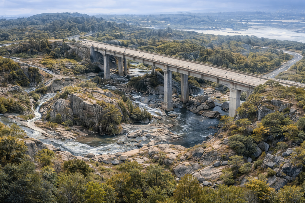
Bridge-corrected Terrain Modelling
Engineering-ready terrain models that resolve LiDAR blind spots
Standard LiDAR and public DEM products often fail around bridges and complex infrastructure. Under-bridge geometry is commonly removed or simplified, causing structures to behave like dams in hydraulic models and introducing uncertainty at critical flow constrictions.
We correct these failures by capturing and modelling the actual under-bridge geometry — including soffits, piers, abutments, and channel continuity — using targeted under-bridge drone photogrammetry. This measured geometry replaces interpolated assumptions at the structure, restoring realistic flow paths while preserving the wider catchment terrain used in existing models.
The result is a hydraulically conditioned Digital Terrain Model (DTM) that reflects how water behaves at the bridge in reality, supporting flood modelling, structural assessment, and infrastructure planning with greater confidence.
At bridges, small geometric assumptions can produce disproportionately large hydraulic errors. We focus measurement effort where model sensitivity is highest.
Where standard terrain data breaks down
- Public LiDAR and off-the-shelf DEMs often fail around bridges, culverts, and complex infrastructure.
- In flood modelling and engineering analysis, these gaps can cause bridges to behave like dams, block flow paths, or hide critical under-structure geometry.
- We focus on correcting terrain where these datasets are known to break — before modelling or design decisions are made.
Our approach
- Measured under-bridge capture where LiDAR cannot see
- Terrain conditioning to remove false obstructions and restore true flow paths
- Bridge-corrected DSM and DTM generation aligned to existing terrain models
- Outputs prepared for hydraulic modelling (HEC-RAS), GIS platforms (ArcGIS / QGIS), and technical visualisation workflows.
- Reduced modelling uncertainty at critical structures
What we deliver
- Bridge-corrected Digital Terrain Models (DTM) (GeoTIFF)
- Under-bridge void and clearance geometry
- Deck, pier, and abutment surface models
- Hydraulically conditioned terrain surfaces
- HEC-RAS-ready terrain and geometry
- GIS-ready 3D models (OBJ / SLPK / multipatch)
- Integration with existing LiDAR and survey data
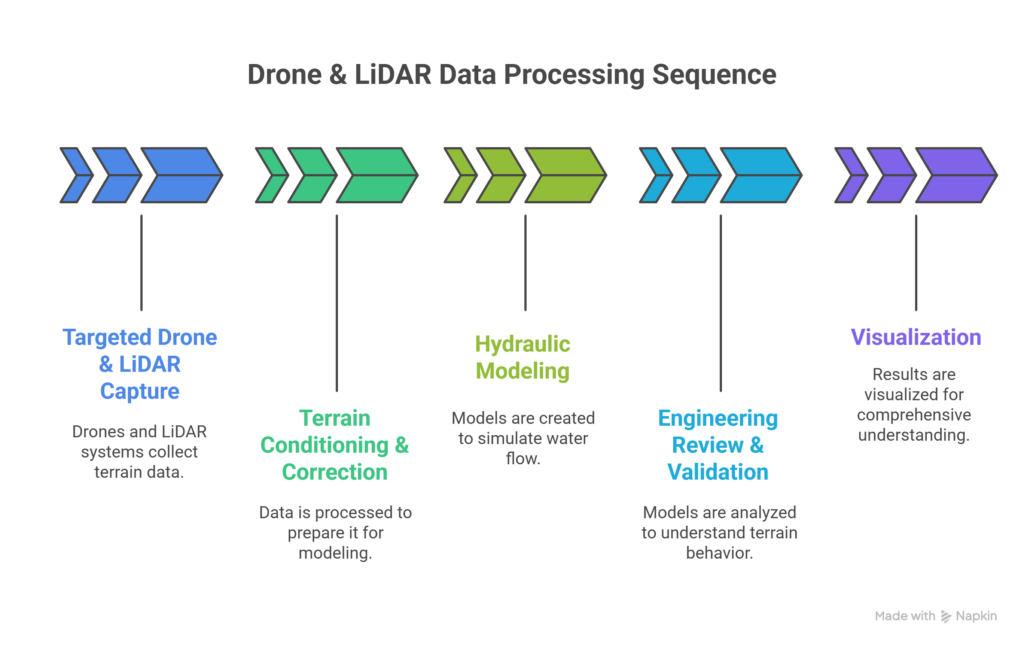
How infrastructure-grade terrain is produced
From targeted capture through to engineering-ready terrain used in hydraulic and design workflows.
We focus on improving confidence at critical structures without altering the wider catchment model.
Let’s discuss how infrastructure-grade reality capture can reduce modelling risk before design decisions are made.
 Get in touch 020 4092 6422